

Tuesday May 20, 2014
Do you know what I was doing this morning at 4 am? I was lying awake in bed, thinking off all the terrible things that could happen to us as we cross the Atlantic in a few weeks. Here’s another fun question for you. Do you know how many boats were abandoned just last week while taking the same route that we are? Two!! That’s right. Two boats with a larger number and more experienced crew than the two of us had to leave their boats behind while making the same trip we’re about to do. I am FREAKING out here people! Granted, both of those boats appeared to be passing through a very nasty low pressure system a few hundred miles east of the United States around the 40th degree latitude, but all I could think of through the whole night was ‘That could be us!’. One of the two crews was picked up by the USCG, but the other crew, as I currently write this, are still missing; their boat believed to be abandoned in the Northern Atlantic.* Pardon my French, but that is some scary shit!
For the weeks and month leading up to our departure from Miami and across the Atlantic to the Azores and then through Gibraltar, I’ve tried to mentally prepare myself as much as possible. Prepare for the monotony of being at sea for 30 straight days, and prepare for the onset of at least 2-3 fairly rough storms during our crossing. In my mind, and according to most of the books I’m reading, the worst part of these storms usually pass you in a few hours and all you’re left with after is maybe a day or two of overcast skies with some rain and the drudgery of waiting for the seas to settle back to their original state. The weather systems that we’ve been tracking for the past few weeks though to get a feel for what’s going on out on these waters, is showing a completely different story.
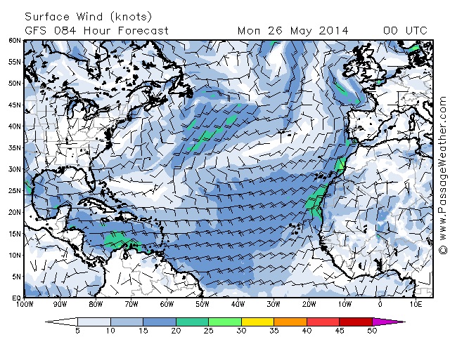
I will admit to you now that we have never once listened to a Chris Parker forecast. We have taken his information while cruising with friends that do get up at the ungodly hour of 6 am to listen, but personally we’ve always been fans of Passage Weather and have used that to prepare for any passage we’ve taken. This does require internet, of which we will not have once we leave on our crossing, but at that point we’ll be relying on downloading forecasts from our SSB twice daily, something that should give us a four day outlook that will be very similar to what we’ve always viewed on Passage Weather. While keeping an eye on it at the moment though, these are the kind of images that we keep seeing pop up.
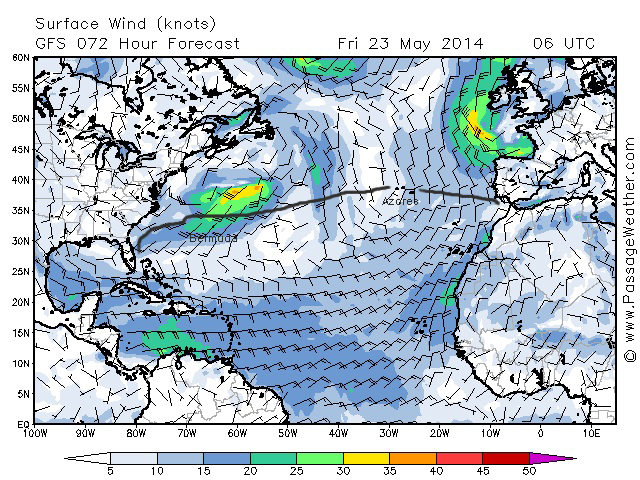
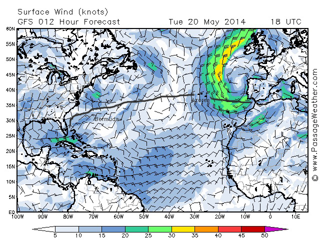
You can see where I’ve labeled Bermuda and the Azores, and our approximate intended route (terrible job with the paint brush, I know). You can also see all that yellow and orange showing up in areas close to where we’ll be, and that’s very, very bad. If you follow the wind indicator at the bottom, you’ll see that yellow represents winds of 30-35 knots, and orange represents 35-40 knots. That would be bad enough on it’s own, but I may have mentioned to you before of our learning of reading Passage Weather, and have pretty much found it to be true. Always expect 5-10 knots higher than it shows. If it’s reading 30-35 knots, expect 35-45. If it’s reading 35-40, well, you’re S.O.L. It’s why we never go anywhere when a forecast is reading over 20 knots. Even though we always travel in weather that shows 15-20, we experience at least 30 knots sometime during the trip. Every.Single.Time.
So you can imagine why these images are getting under my skin. They never end. There might be two days of calm in those areas before another front develops. This is not normal, not for this late in the season, and it has me terrified that nothing will change before our intended June 1st departure date.
So as I laid there wide awake, waiting for the sun to come up, my mind was filled with alternative routes. I was thinking to myself, ‘You know, since we were about to take on a 30 day passage anyway, we could make it to Panama in 10-12. And you know who’s in Panama? Brian and Stephanie on Rode Trip. That would be so fun!!’. I actually lulled myself to sleep with false promises that we would stick to the Caribbean where we would never be more than 200 miles from some form of land.
Reality did set in this morning though as I realized the light of a few very important things. 1. We don’t have to go if everything is showing the same in a week and a half. Have those fronts not showed any sign of leaving, we will wait for them to do so. Or, hightail it to Panama. 2. Based on years and years of data, they should be changing any day now. The Bermuda/Azores high should be settling in, and things should start to look much calmer on those waters. And 3. Downloading a 96 hour forecast twice a day should keep us on top of any fronts that could arise. If we see anything that looks like it’s coming up, we have no problem backtracking or adding extra miles to avoid it. We are going to be very cautious cruisers on this trip, and that is fine by me. I would much rather arrive even a week later than anticipated if it means we’re not surfing down 20 ft waves in 40 knot winds. Ever.
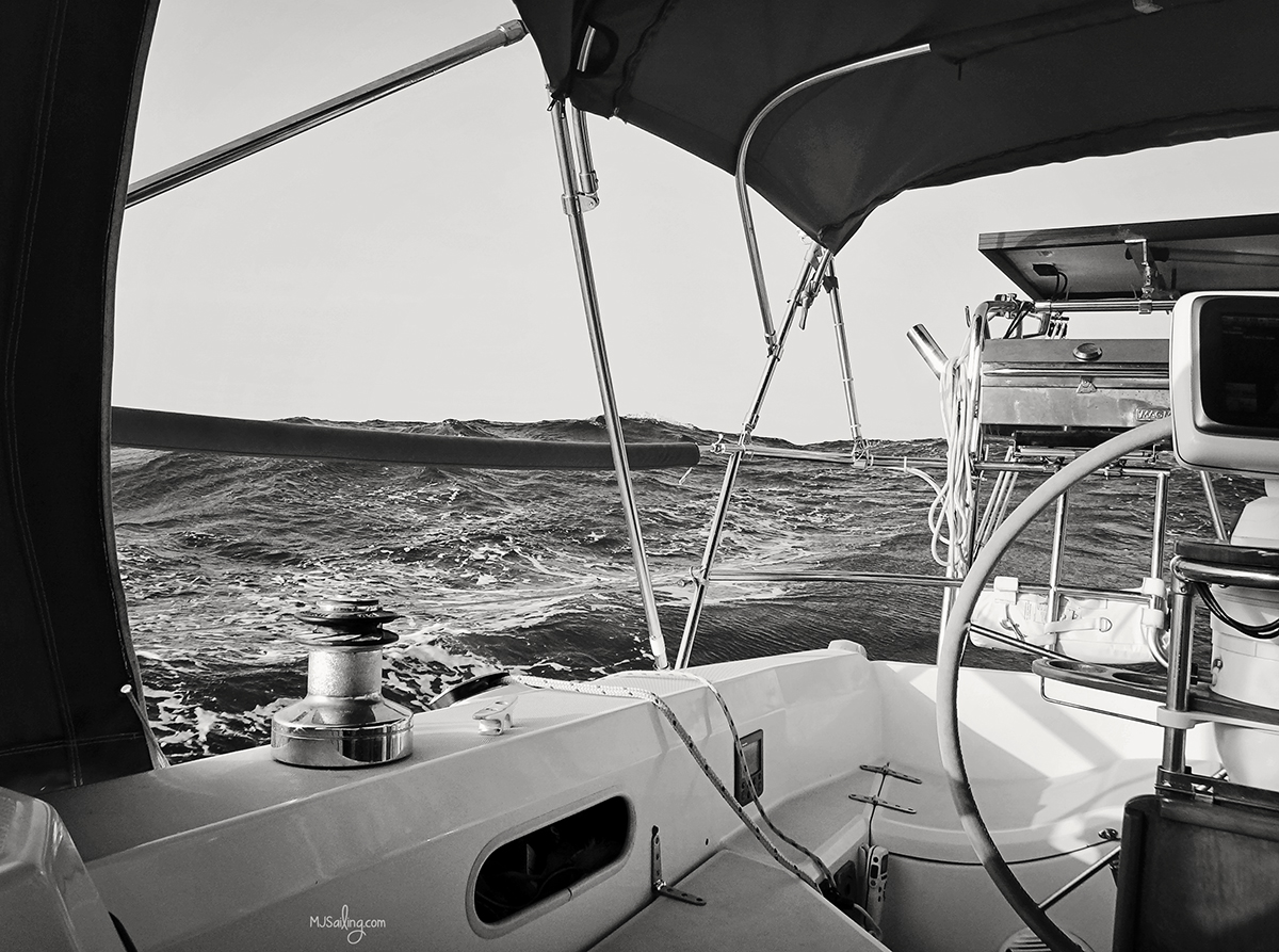
Now this is the kind of weather I’m looking for!
* On Friday May 23rd, the USCG found the hull of this second boat, the Cheeki Rafiki, but with no sign of the crew. Â The life raft was still on board and never inflated.